New Google Maps for iOS brings vectors, transit and navigation features
 Daniel Eran Dilger
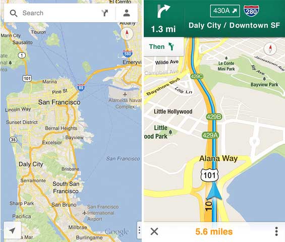
Google's newly released standalone Google Maps app for iOS users brings new features and a familiar look along with new technology previously only available on the company's own Android platform, providing iOS users with a more credible alternative to Apple's own new iOS 6 Maps app than Google's existing web app.
Google vector maps for iOS
The new Google Maps uses vector imaging just like Apple's Maps, resulting in a similar information scaling that incrementally displays new data as you zoom in. Like Apple's Maps, Google now presents live 3D building models that appear only when you zoom into the block level.
Previously, Google Maps on iOS 5 and earlier (or via the company's very limited web app) loaded bit mapped tiles incorporating a static view of building outlines. The older maps also could not be freely rotated, and text labels were fixed at specific zoom levels.
While Google had earlier incorporated a vector-based maps presentation in its Android app, it could not force Apple to use this data in the Maps client bundled with iOS. This allowed Apple to launch its own Maps app this summer with the first vector based maps seen on the platform.
Vector-based maps can be highly efficient, allowing users to freely roam offline much further than the bit mapped tiles Google serves over the web (and in previous incarnations of Google Maps on iOS).
Apple's own version of Maps seems to present and cache more mapping detail for automatic offline use, and currently appears to load new data in the background faster over a slow connection. However, the new Google Maps is a marked improvement over Google's earlier bitmapped editions (and in particular, over the company's web app).
After zooming into San Francisco and then Berlin, Germany, and then taking the app offline, Google Maps was still able to navigate some street level maps in both cities without a data connection. However, maps of the surrounding area (and at other zoom levels) were not as clear or complete as Apple's Maps.
The features of Google Maps for iOS are now closer inline with the company's Android app, although both versions still include the same place name errors, with many businesses located in the middle of the street or identifying the wrong location (as will be detailed in our upcoming segment on local data and points of interest).
Flyover features delegated to Google Earth
Another significant omission in Google Maps is support for 3D satellite images similar to Apple's Flyover. Rather than incorporating its own Google Earth data into the new Google Maps app, the company simply links to its existing Google Earth app.
Apple's Maps presents Standard street maps and Satellite image maps (or a Hybrid combination), each with a 3D perspective option (at least on newer iOS devices that can support the 3D features, such as the iPhone 4S or newer).
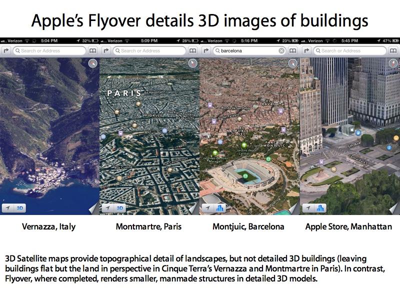
The new Google Maps similarly offers 3D perspective with grey building outlines just like Apple's Standard mode, but only shows satellite views in flat perspective, just like Apple's Maps do in areas where Flyover isn't available (and as Android's Maps+Navigation app does). While both apps show mountain landscapes in topographical 3D perspective, only Apple currently incorporates 3D satellite building models in major cities supporting Flyover.
To see a similar Flyover-like view of 3D buildings, you have to exit Google Maps and launch Google Earth (available as a link within the new app). However, Google Earth images are much older than Apple's Flyover, and contain many of the same imaging bugs that critics bewailed regarding Apple's Flyover at its launch.
In Google Earth, the San Francisco Golden Gate Bridge appears to have a layer of pavement running underneath it (below), for example, while Apple renders the landmark correctly in iOS 6 Map's Flyover.
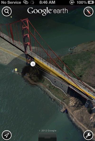
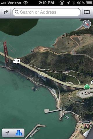
And the connecting Doyle Drive highway, which has been under construction for years, is still shown pre-construction, depicting closed ramps and old bridges as still in use while none of the newly completed roads and tunnels are even visible in Google Earth's version of 3D maps. Apple's Flyover maps show the same areas correctly with more up to date 3D images, more comparable to Google Map's new but flat satellite images.

Google Transit
For cities where Google presents useful transit data, the new Google Maps offers integrated transit lines and stop information. Apple's Maps present only sporadic metro stop markers and must rely on third party transit apps to calculate routes.
Apple's approach provides users with more options to obtain route information (useful in cities where Google presents incorrect or no transit information), but lacks the simplicity of Google's integrated app.
As AppleInsider previously detailed, Google provides excellent transit data in some cities (such as Portland, Oregon, where Google Transit got started), provides fair information in others (unreliable Muni arrival times in San Francisco, no bus or tram data in Berlin outside the major U-bahn and S-bahn routes) and nothing more than metro stops in others (Google provides no transit data in Paris or the rest of France, for example).
Google Transit still delivers (below) the same nonsensical transit routing for Berlin we detailed earlier (above), because it doesn't incorporate transit data for most of the city's public transit vehicles.
With both Google Maps and Apple Maps, iOS users can now pick which approach works for them in the location they are navigating. Google provides detailed station and route information in Japan that Apple's Maps lack, for example, while in other cities Apple and its third party helper apps can calculate transit routes Google Maps doesn't.
Google Navigation
Also new in Google Maps for iOS is the company's turn by turn driving directions, which were previously kept as an exclusive feature for Android. Apple developed its own driving directions for iOS 6 Maps, with voice guidance and route timing based on live traffic data.
With Google Maps, users now have multiple options for driving directions. In initial testing, Apple's version appears slicker, with rich looking 2D or 3D map images tailored for driving.
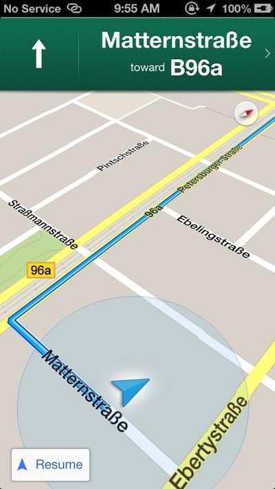
Google's presentation is simpler, but clean and easy to read, with larger directional information. Both present route options with estimated driving times.

Google warns users that its driving directions are in beta, nothing that "directions may be inaccurate, incomplete, dangerous or prohibited," adding that "traffic data is not real-time, and location accuracy can not be guaranteed."
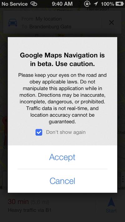
The company's warnings appeared aimed at deflecting the kind of sensational reporting that has dogged Apple's Maps, including a recent report that detailed how authorities in a bleak desert area of Australia have beseeched the global public not to go looking for a small town blindly using Apple's formerly incorrect directions, for fear they might drive into the desert with no food or water and limited gas, with full confidence in a GPS app to shield them from any sort of unforeseen consequences of their poor planning (something people have been doing for nearly a decade prior to the release of Apple's Maps).
Now that Google (and Nokia) have released their own standalone maps clients for iOS, AppleInsider can continue its detailed comparison of Apple Maps and other mapping options for local search, driving directions and traffic data.
4: Map labels & local search
5: Routing & traffic


 Malcolm Owen
 William Gallagher
 Mike Wuerthele and Malcolm Owen
 Sponsored Content

 Chip Loder
 Andrew Orr